

In Portland, 15-Minute Neighborhoods Focus on the People
Hello from rainy Portland!
Over the last few days, my wife and I have been bouncing back and forth between several places in the Pacific Northwest. We left Seattle for Portland on Saturday last week, stayed with family for the night, and left again for a brief stay on the Pacific coast. We're back today in Portland and settling in for a few days.
If you know us, our road trip to the PNW has become a bi-annual tradition. We've gone as far as Vancouver, BC on past trips, but due to Covid-19 immigration restrictions, we were restricted to our typical Seattle—Portland itinerary.
Partly because we have family in the area, but also because of its rapid growth in recent years, both Seattle and Portland have been amazing destinations well-suited for our outdoorsy inclinations and foodie tendencies.
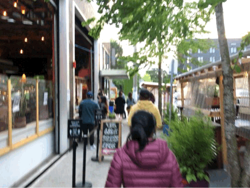
A casual walk down a side street off of NE Failing, where parklets and service windows are common.
Our love for Portland, in particular, is very apparent, but outside the common local attractions there's another more subtle reason — it just feels friendlier.
This time around, we were surprised by yet another checklist of amazing restaurants that we haven't tried or are brand new, including Fair Weather, a wonderful corner restaurant and cafe in the "lower right" region of Ladd's Addition, and Obon Shokudo, a vegan Japanese comfort food restaurant located in Buckman.
Both restaurants stand out in their respective neighborhoods as high-quality, trendy, and affordable food options in areas with a strong neighborhood vibe. And with a car during the Covid-19 takeout-style of dining, picking up from high-demand restaurants has never been easier. That said, with a pup that joins us on the road, we typically accompany our pick-up orders with a short 10-15 minute walk around the neighborhoods — this is where Portland shines.
Walkability may not be top of mind for the average Portland tourist like it is in New York City, but it's a clear benefit if you're staying on the Eastside of the river. Nearly every neighborhood on the Eastside of Portland features a wonderful new restaurant or neighborhood institution that anchors public thoroughfare — featuring a combination of lively walking culture with convenient corner markets and small local businesses cozily mixed in with commercial complexes, light industrial, and modern one-plus-five mid-rise apartments.
This large-scale neighborhood wasn't an accident.
Portland has a history of confronting highway expansion efforts that ODOT planners have long proposed would benefit locals by connecting major parts of the city with accessible highways that significantly reduce congestion on local roads and arterials without creating a significant environmental impact on the surrounding areas, which include a diverse middle school located in a historically Black neighborhood.
As late as 1960, highway infrastructure planners between states have been proposing multi-billion dollar efforts to increase sections of I-405, and I-84, in addition to the extension of I-205 with the simple premise of relieving traffic.
But time after time, local coalitions, economists, and environmentalists have fought back, pointing to a clear lack of evidence or data that supports the claim, instead pointing to empirical evidence that suggests the opposite — not only does highway construction disturb, destroy, and separate neighborhoods, but the widening of roads has never solved congestion based on a well-documented urban planning concept called induced demand.
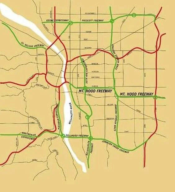
Take this highway map designed by mid-century planners, which proposed the construction of an elaborate freeway maze on the Eastside of Portland, which included a wide highway called the Mt. Hood Freeway that would pass through the heart of SE Portland, directly over Ladd's Addition.
Compare it to my personalized Google Map, which features a list of my favorite spots and new recommendations, clearly delineating prominent "5-block neighborhoods" on the Eastside, flanked by bustling semi-commercial streets like SE Division, SE Hawthorne, and E Burnside.
This organic, century-old city plan has evolved over time with community-led input, creating a natural 15-minute city.

A personalized Google Map with my favorite new and old restaurants and shops, representing large uninterrupted neighborhood blocks surrounded by mixed residential-commercial streets bursting with acclaimed restaurants and local shops.
It's easy to see how a network of overhead highways would disturb countless neighborhoods, physically clearing a path of established homes and uninterrupted walkways in exchange for concrete infrastructure that causes a ripple effect of environmental impact due to overhead diesel trucks and general roadway emissions (that already account for more than 40% of the city's emissions).
Data as a mediator and advocator
Yet, ODOT and the Interstate Bridge Replacement Program continue to forge ahead, challenging local anti-highway sentiment with multi-million dollar plans proposing multi-billion dollar construction, all based on loose data, historical reference, and expert opinion. And although local coalitions like No More Freeway Expansions Coalition and expert economists like Joe Cortright at CityObservatory have tipped the scales against highway expansions, it's not without continued debate.
This is the role data should play — a bi-partisan, scientific mediator to the competing viewpoints. With data from platforms like Replica Scenario, UrbanFootprint, or State of Place, creating synthetic scenarios for various building plans can quickly quantify impact including:
the short-term impact of construction on neighborhoods
the long-term impact of highways on the environment (macro and micro)
the long-term impact of highways on social construct (equity, access)
the short and long-term impact of highways, on-ramps, and off-ramps on safety, congestion, and accessibility
the long-term impact on local real estate pricing and related social impact on neighborhoods separated from city cores and waterfront areas
Forecasting platforms and data-rich inputs can help highway planners, urban planners, neighborhoods, and policymakers find a common ground to begin negotiations. A combination of federal census data, local demographic data, and depersonalized street data can design scenarios that account for the economic and social goals without incurring millions of tax dollars on dead-end plans or donation dollars that fall on deaf ears.
Rich data and sophisticated modeling stand to be the global unifier in a decades-long debate for highway expansion that's begging for civil conversations and shared interest.